We are looking for your feedback on our draft regulation mapping!
NVCA has the responsibility to regulate development in natural hazard areas in order to avoid the loss of life and damage to property due to flooding and erosion.
Learn more about the natural hazards found in our watershed here.
Public Open House – April 8, 2025
Property owners are welcome to attend our public open house on April 8, 2025, from 5:30 p.m. to 8:00 p.m. to review regulation changes with an NVCA staff member.
If you are unable to attend the open house, you can schedule an appointment with NVCA’s Regulations staff to discuss your questions and concerns.
How was the draft regulation mapping updated?
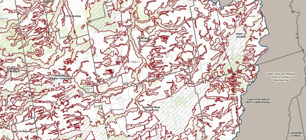
NVCA has updated its Regulations Mapping using the best available information and data collection techniques that helps us make better planning decisions for future development and help make the Nottawasaga Watershed safer for our communities.
The draft regulation mapping layers can now be viewed on our interactive tool, which highlights areas where natural hazards may occur in the watershed. If your property is in a regulated area, you may require approval from NVCA before starting your project.
Key Updates:
- Overall Regulation Area: Between 2013 and 2024, the total regulated area decreased by 18.6% (32,061 hectares).
- Wetlands: 4,296 wetland boundaries updated
- Slopes: 580 slope stability hazard areas updated
- Floodplains: 2,121 hectares of floodplain mapping updated in the Upper Mad River subwatershed and the Lower Nottawasaga River reach.
- Shoreline: 42 km of shoreline hazard mapping updated