Welcome to our July newsletter: as always, we're excited to share with you the latest updates and developments from the world of integrated hydro..
͏ ͏ ͏ ͏ ͏ ͏ ͏ ͏ ͏ ͏ ͏ ͏ ͏ ͏ ͏ ͏ ͏ ͏ ͏ ͏ ͏ ͏ ͏ ͏ ͏ ͏ ͏ ͏ ͏ ͏ ͏ ͏ ͏ ͏ ͏ ͏ ͏ ͏ ͏ ͏ ͏ ͏ ͏ ͏ ͏ ͏ ͏ ͏ ͏ ͏ ͏ ͏ ͏ ͏ ͏ ͏ ͏ ͏ ͏ ͏ ͏ ͏ ͏ ͏ ͏ ͏ ͏ ͏ ͏ ͏ ͏ ͏ ͏ ͏ ͏ ͏
| Message from the President
As summer progresses, we’re excited to share some exciting updates from across the Aquanty community. This month’s HydroGeoSphere (HGS) software sale brought in a wave of new interest. We want to extend our thanks to everyone who reached out to learn about HGS for the first time. |
|
|
| |
|
|
| Your support reinforces our commitment to delivering the world’s most advanced, fully-integrated hydrologic modelling software.
I also want to reiterate last month's exciting news, just in case you missed it. Both HydroSphereAI and our close partners at the Manitoba Forage and Grassland Association (MFGA) were named finalists for this year’s Water Canada Awards. It’s an honour for our latest innovations and ongoing projects to be recognized in two categories 1) New Tech Award and 2) Early Adopter/Innovation Partnership Award. We’re proud of the progress these projects are making in the water sector.
Finally, we’d like to acknowledge the success of our recent webinar in partnership with the Ontario Water Consortium, which is now available to view below in this newsletter. We’re also pleased to highlight our new partnership with the Centre for Agri-Food Benchmarking as a Coalition Partner. Together, we aim to advance water resource modelling in Canada’s agri-food sector and support the Centre’s mission to develop stronger benchmarks for sustainable outcomes. These are important steps toward driving water innovation across the country.
Thank you for staying connected with us. We’re looking forward to a strong finish to the summer and encourage you to follow our blog and LinkedIn for updates on upcoming events, webinars and future opportunities.
|
|
|
| |
|
|
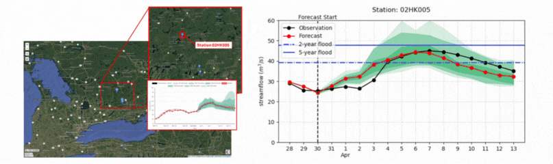
| This month we published our second HydroSphereAI case study, showcasing how our machine-learning-based forecasting platform performed during a high-flow event on the Crowe River near Glen Alda this past spring. HydroSphereAI’s ensemble forecasts consistently identified April 6 as the key date for peak flows and adapted in real time as new data came in— capturing both the timing and magnitude of the peak within its probabilistic range. The case study highlights the power of AI-driven forecasting to enhance preparedness and its potential to support flood response efforts. Check out the full case study on our blog. |
|
|
| |
|
|
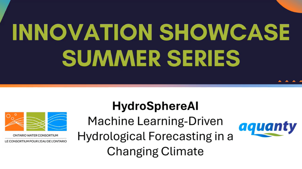
| Webinar Recap: HydroSphereAI with the Ontario Water Consortium Earlier this month, Aquanty's Dr. Andre Erler hosted a 45-minute webinar in collaboration with the Ontario Water Consortium, showcasing HydroSphereAI. The session walked through HSAI’s machine-learning engine, our beta test in Ontario, and how it supports climate adaptation and flood forecasting with real-time streamflow predictions. |
|
|
| |
|
|
| Assessing the Sensitivity of Subsurface Mine-Dewatering Simulations to Surface Water Representation Webinar Join us next month for an insightful session exploring how climate change can influence mine dewatering strategies, featuring cutting-edge integrated hydrologic modelling approaches. Learn how fully coupled groundwater–surface water models compare to traditional approaches, and the importance of incorporating surface flows for subsurface mine water management.
Date: Wednesday, August 13 | 12:00 PM 1:00 PM
Presenter: Andrea Brookfield, Associate Professor in the Earth and Environmental Sciences Department at the University of Waterloo |
|
|
| |
|
|
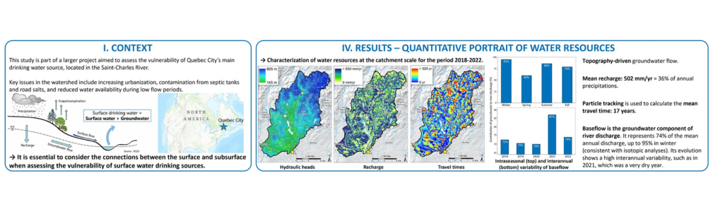
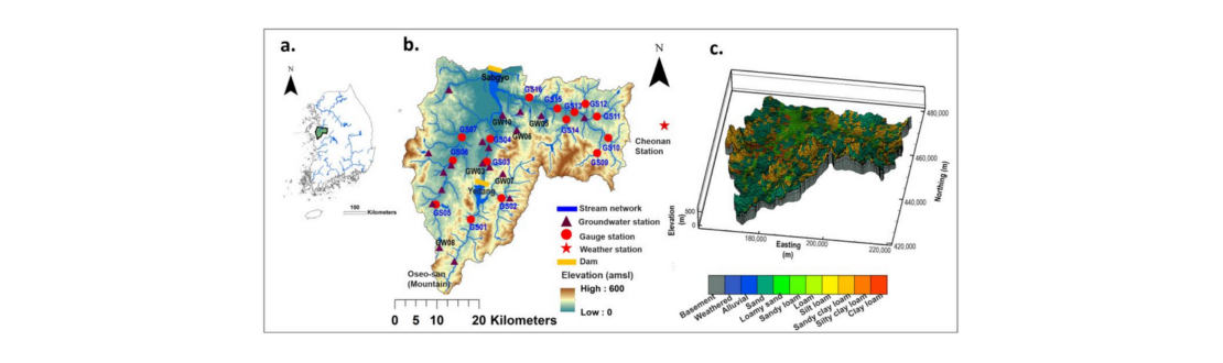
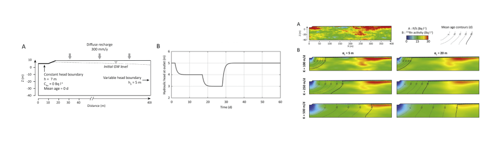
| Source Water Protection in Quebec City: Using an integrated 3D hydrological model to investigate surface water-groundwater interactions In this HydroGeoSphere research highlight, researchers used a fully integrated 3D hydrological model to investigate surface water–groundwater interactions in the Saint-Charles River watershed, which supplies drinking water to Quebec City. Using HydroGeoSphere’s particle tracking and the Hydraulic Mixing-Cell method, the team revealed an average groundwater residence time of 17 years and spatial variability in flow paths. The work provides a decision-support tool for managing land use and protecting drinking water in the face of climate change and the pressures of increasing urbanization.
Read More.
|
|
|
| |
|
|
| Congratulation are due to Stephanie Bringeland, PhD candidate from Queen's University in the Department of Geological Sciences and Geological Engineering. Stephanie was awarded the IAH - International Association of Hydrogeologists Tóth Award for her presentation at the GAC-MAC-IAH-CNC 2025 conference that took place in Ottawa last month.
Stephanie presented her research entitled “Analysis of total water storage variability in Southern Alberta with GRACE/GRACE-FO observations and fully-integrated groundwater – surface water modelling” co-authored with collaborators from Aquanty, Queen’s University, and Alberta Environment and Protected Areas.
In this research, Stephanie draws upon the framework and fully-integrated hydrologic modelling with HydroGeoSphere to help analyze and validate water storage observations produced by the Gravity Recovery and Climate Experiment (GRACE) Follow-On (GRACE-FO) project. GRACE/GRACE-FO is a joint project by NASA and the German Research Centre for Geosciences (GFZ) which uses remote sensing/satellites to track Earth's water movement to monitor changes in underground water storage, the amount of water in large lakes and rivers, soil moisture, ice sheets and glaciers, and sea level caused by the addition of water to the ocean. |
|
|
| |
|
|
| Intro to HydroGeoSphereNext session: July 9, 2025
Every month Aquanty's technical sales lead Brayden McNeill delivers a FREE half-day training session. Our Introduction to HydroGeoSphere training sessions cover essential topics such as the basic HGS workflow, the essential components of a *.grok file and visualizing model results. |
|
|
| |
|
|
| Find our monthly HGS software update on our 'HGS Downloads' page, the July 2025 software update is now available. This release delivers major performance improvements by overhauling the data layout of binary output files for vector and tensor fields.
Highlights include:
1. Binary files (e.g., prefixo.v_pm.XXXX, prefixo.ElemK_pm.XXXX) now use a structure of arrays format.
2. Faster read/write operations = faster model runtimes.
3. Significant reduction in binary file sizes:
– ~40% smaller for 4-byte vector fields (3 components)
– ~25% smaller for 8-byte vector fields (3 components)
These changes are especially impactful for large simulations with high-frequency output.
As always, we are committed to the continued improvement to the user experience. Do you have suggestions for new commands or improvements to the user experience? Send your ideas to [email protected]!
Read the release notes to see recent improvements to HydroGeoSphere. |
|
|
|
|
| |
|
|
| Copyright © 2025 Aquanty Inc., All rights reserved.
Aquanty Inc., 600 Weber St.N., Unit B, Waterloo, ON N2V1K4, Canada, (519)-279-1080 [email protected] |
|
|
| |
|
|

|