Welcome to our February newsletter: as always, we're excited to share with you the latest updates and developments from the world of integrated hydro..
͏ ͏ ͏ ͏ ͏ ͏ ͏ ͏ ͏ ͏ ͏ ͏ ͏ ͏ ͏ ͏ ͏ ͏ ͏ ͏ ͏ ͏ ͏ ͏ ͏ ͏ ͏ ͏ ͏ ͏ ͏ ͏ ͏ ͏ ͏ ͏ ͏ ͏ ͏ ͏ ͏ ͏ ͏ ͏ ͏ ͏ ͏ ͏ ͏ ͏ ͏ ͏ ͏ ͏ ͏ ͏ ͏ ͏ ͏ ͏ ͏ ͏ ͏ ͏ ͏ ͏ ͏ ͏ ͏ ͏ ͏ ͏ ͏ ͏ ͏ ͏
| Message from the President
As we move into March, we're excited to share some key updates from the past month at Aquanty. From impactful industry events to major advancements in our research and technology, 2025 is off to a strong start!
|
|
|
| |
|
|
| With winter storms sweeping across Ontario in recent weeks, it’s a great time to explore how our HydroClimateSight platform supports snowpack monitoring and forecasting. Our latest blog post covers the platform’s historical and forecasted Snow Water Equivalent (SWE) data, with 7-day and 32-day SWE forecasts powered by the iSnobal model. We’re also working on an exciting new machine-learning-based method for SWE prediction— stay tuned!
|
|
We had a great time at the CWRA 2025 National Midterm Workshop on January 31st. Brayden McNeill and Andre Erler represented Aquanty, sharing insights on the evolving role of integrated modelling for drought forecasting. Our presentation sparked significant interest, and as a sponsor, we’re proud to support these important discussions on sustainable water management. Thanks to CWRA for hosting an engaging and insightful event!
|
|
We were also proud to participate in the Modelling of Controlled Drainage session by CANCID. Special thanks to Steve Frey for his excellent presentation on tile drainage management and HGS modelling, showcasing HGS’s ability to simulate complex watershed conditions at various scales.
|
|
Additionally, Steve Frey presented at the Ontario Groundwater Geosciences (OGS) Open House 2025, where he discussed integrating Earth observation data into HGS calibration and validation to enhance hydrologic modeling accuracy for water resource management. |
|
Lastly, we're trying to plan out a schedule of webinars for 2025 and into 2026. If you have any topics of interest that you'd like the Aquanty/ HydroGeoSphere team to cover, or if you have any interesting research applications that you'd like to present to the Aquanty network please reach out about the possibility of delivering a webinar! - Steve Berg, President & CEO, Aquanty Inc. |
|
|
| |
|
|
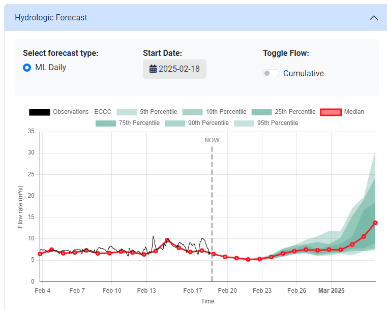
| HydroSphereAI Beta Test Update The HydroSphereAI Beta Test is officially underway! On February 4th, we wrapped up our beta test kickoff meeting with conservation authorities across Ontario, introducing HydroSphereAI, outlining key objectives, and providing a live demonstration of the platform. The session generated a lot of great engagement, setting the stage for a successful beta test. |
|
Thanks to everyone who joined and contributed— your insights will be instrumental in shaping the future of HydroSphereAI! We look forward to working closely with flood forecasting and water resources professionals across Ontario to support conservation authorities in their mandate to protect people and property from flooding, as well as conserve natural resources for economic, social, and environmental benefits. If you work for a conservation authority or know someone who does, we’d love for you to participate in the ongoing beta test. This is an exciting opportunity to help shape the future of streamflow forecasting and water resource management.
Reach out to us at [email protected] to learn more about how you can participate in the HydroSphereAI beta test. |
|
|
| |
|
|
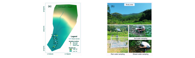
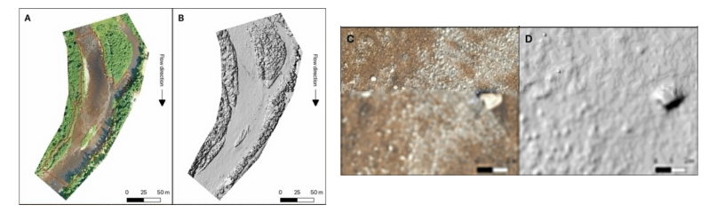
| Water sources and threshold behaviors of streamflow generation in a mountain headwater catchment In this study, researchers focused on the Mukeng headwater catchment in eastern China, conducting an integrated analysis of streamflow generation mechanisms during 244 rainfall events over a five year period. The study aimed to deepen the understanding of how different water sources contribute to streamflow and to quantify the threshold behaviors in both surface and subsurface flow during rainfall events. Researchers utilized HydroGeoSphere (HGS) for surface and subsurface hydrological modelling combined with isotopic tracing, enabling them to distinguish the spatial and temporal origins of streamflow components and their contributions to runoff. Read More.
|
|
|
| |
|
|
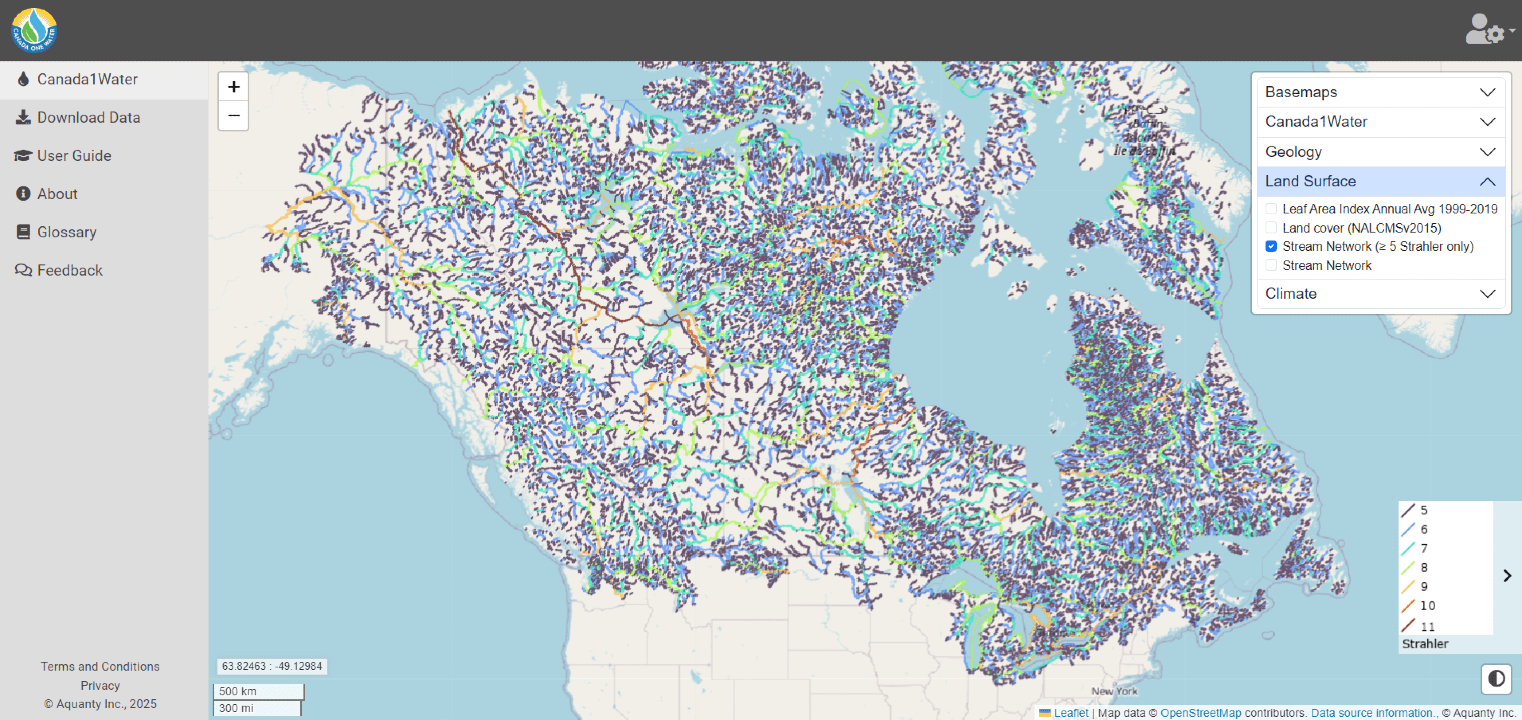
| Canada1Water Update
We’re excited to announce the release of the first dataset on the Canada1Water portal! Developed by Aquanty’s Eric Kessel, the Canada1Water (C1W) Stream Network Dataset enhances the National Hydro Network (NHN) by correcting topological errors and introducing standardized Strahler stream order classification, improving hydrological modeling accuracy across Canada.
|
|
With seamless integration across provincial borders and into U.S. watersheds, it supports flood risk management, ecological restoration, and sustainable water use, while also enhancing HydroGeoSphere (HGS) simulations for detailed water movement analysis Click here to learn more and explore the dataset. |
|
Canada1Water had a strong presence at recent government and industry events. At the 10th Annual Ontario Groundwater Geosciences Open House, project partner Heather Crow highlighted research from the C1W Phase 2 Data Enhancement Activity, which focuses on upgrading Canada1Water’s infrastructure, primary input datasets, and model verification. The event also featured two key presentations from C1W co-Principal Investigators: - Canada1Water - Recap of Phase 1 and Introduction to Phase 2: Ontario Context by Dr. Hazen Russell
- The Progressive Refinement of Earth Observation Data Usage within Canada1Water: Examples from Ontario by Dr. Steve Frey
In addition, Agriculture and Agri-Food Canada (AAFC) recently highlighted Canada1Water’s role in predicting floods, droughts, and water resource challenges in their latest feature. As the first-of-its-kind 3D model of Canada’s water cycle, C1W is shaping the future of water management in Canada. The C1W data library and model framework could be used to zoom in on smaller, local-scale areas such as this pictured example of a 3,446 km2 watershed in Ontario.
Read more about how Canada1Water is making a difference. Additionally, here is a roundup of the big picture "Water Issues" highlighted on the C1W blog this month: - The Guardian - ‘The water war’: how drought threatens survival of Sicily’s towns
- The Conversation - Water is the other US-Mexico border crisis, and the supply crunch is getting worse
- CBC News - Climate disasters lead to billions in insurance losses. Could they trigger a financial crisis?
|
|
|
| |
|
|
| Intro to HydroGeoSphereNext session: March 5, 2025
Every month Aquanty's technical sales lead Brayden McNeill delivers a FREE half-day training session. Our Introduction to HydroGeoSphere training sessions cover essential topics such as the basic HGS workflow, the essential components of a *.grok file and using Tecplot 360 to visualize model results. |
|
|
| |
|
|
| Find our monthly HGS software update on our 'HGS Downloads' page, the February 2025 software update is now available. The latest update features exciting enhancements for your simulations! This month's update enhances visualization accuracy, evapotranspiration settings, and groundwater table depth calculations.
1. Improve Tecplot and VTU outputs to resolve visualization artifacts, ensuring more accurate representation of simulation results.
2. Enhance default evapotranspiration (ET) properties by introducing pressure-head-based limits for transpiration and evaporation, giving users more control over ET processes.
3. Introduce the new command interpolate depth to groundwater (GW) table to improve the accuracy of groundwater table depth calculations.
As always, we are committed to the continued improvement to the user experience. Do you have suggestions for new commands or improvements to the user experience? Send your ideas to [email protected]!
Read the release notes to see recent improvements to HydroGeoSphere. |
|
|
|
|
| |
|
|
| Copyright © 2025 Aquanty Inc., All rights reserved.
Aquanty Inc., 600 Weber St.N., Unit B, Waterloo, ON N2V1K4, Canada, (519)-279-1080 [email protected] |
|
|
| |
|
|

|